Death Valley national park
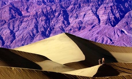
It sounds like a place to avoid, but don’t let the ominous name scare you away. Most of the year, this vast and rugged expanse of east Californian desert is brutally hot, but visit in winter or early spring (though even in the dead of winter, midday temperatures can hit 30C) and you’ll find a surprisingly beautiful and vibrant place. First-time visitors are often awestruck by the desert’s vivid colours. For thousands of years, the people of the Timbisha tribe thrived here, migrating seasonally between the valley floor and more fertile mountains. The name Death Valley was bestowed in 1849 by a band of lost California-bound gold rushers, one of whom did actually die while trying to cross it. The legend doesn’t seem to deter runners of the Badwater Ultramarathon, a 135-mile race across the vast valley held in mid-July.
The park has nine campsites and several air-conditioned lodges, including the historic Furnace Creek Inn (doubles from $365)and the Panamint Springs resort (doubles from $79, quadruples $94).
Top tip: One of the best places to experience Death Valley in all its multicoloured glory is Zabriskie Point, at sunrise or sunset. This easily accessible viewing point is only a short walk from a large parking area.
Death Valley links history, lodging, Badwater Ultramarathon
Yosemite national park
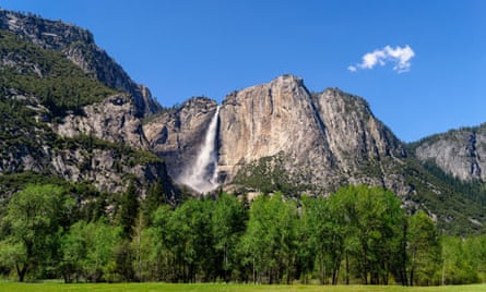
With its stunning glacier-sculpted geology, abundant wildlife and world-class recreational opportunities, Yosemite, 200 miles east of San Francisco, is one of the crown jewels of America’s national park system. Yosemite’s granite wonderland was carved by massive glaciers around three million years ago, when ice covered all but the highest peaks in the Sierra Nevada.
Today, Yosemite valley is known for fantastic hiking, rafting, fishing and wildlife watching, not to mention being a mecca for big-wall rock climbing. A year-round destination, Yosemite is resplendent but often crowded in the summer; winter transforms the park into a quiet snowy paradise. Many park roads and trails are closed or inaccessible from mid-November until late spring, but Yosemite valley stays open year-round for snowshoeing, cross-country and backcountry skiing.
Yosemite is best explored over at least several days. Overnight accommodation ranges from wilderness camping to cabins to the luxurious Ahwahnee Hotel, with doubles from $360 a night.
Top tips Yosemite’s towering granite walls are too tall to be seen through a car windshield; this park is best experienced on foot. The one-mile Glacier Point and 1½-mile Tuolumne Meadow trails offer short but spectacular strolls, or tackle the more strenuous 7.2-mile walk to the top of Yosemite Falls. The harrowing 14-mile hike up Half Dome requires clinging to cables bolted into the rock face, as well as luck in the much-coveted permit lottery.
Yosemite links reservations, walking, how to apply for a Half Dome permit
Point Reyes national seashore
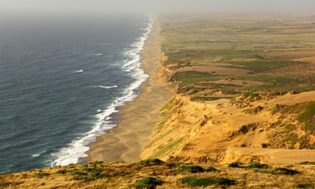
California is known for its beautiful beaches, but those preferring seals and solitude to bikini babes and boardwalks should head to Point Reyes national seashore, 37 miles north of San Francisco. Protected in 1962 to save the area from residential development, the peninsula is one of California’s few wild beaches. The 180-square-mile park is nearly cut off from the mainland by Tomales Bay, an elongated body of water that sits in the rift zone created by the San Andreas fault.
Headlands and sea cliffs provide a sanctuary for wildlife, including raptors and nesting sea birds. A large herd of tule elk – a subspecies that once roamed throughout California – grazes in the northern highlands of the peninsula. Point Reyes is popular year-round, but especially from late December to mid-March, when as many as 20,000 grey whales migrate past the peninsula from their Alaskan feeding grounds to their breeding grounds off Baja California, in the longest migration undertaken by any mammal.
Point Reyes is only an hour north of San Francisco (as long as traffic is moving at a reasonable clip over the Golden Gate bridge), and the park offers backcountry and boat-in camping. Permits and a willingness to rough it are required; no car or RV camping is available. Hiking trails abound: short ones (less than a mile) include the Earthquake trail, which straddles the San Andreas fault, and the Kule Loklo trail, which takes in a restored coastal Miwok Native American village. Those with more time and energy can set off on the US’s longest hike, the 6,800-mile American Discovery Trail, from Point Reyes all the way east to the Atlantic Ocean.
Top tips The only indoor lodging in the park is at the Point Reyes Youth Hostel, which offers dorm beds ($25) and private rooms (from $82, sleep up to five) to travellers of all ages. Reservations highly recommended.
Point Reyes links campsites, whale watching, hiking
Joshua Tree national park
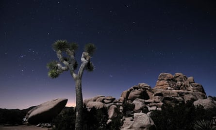
The park was named after the otherworldly trees that dot the landscape – actually an unusually tall species of yucca – but the real stars here are the rock formations: jumbled piles of outsize boulders that glitter with crystals in the southern Californian sun. Rock climbers come from all over the world to scale these boulders, but you don’t have to be a pro to have a blast scrambling around this pink granite jungle gym.
The other stars of Joshua Tree are the stars themselves: with no humidity and skies devoid of light pollution, the Milky Way is overwhelmingly vivid. For an out-of-this-world experience, try scheduling your trip during a meteor shower, such as the Orionids in October, the Leonids in November, or the Geminids in December. Summers in the Mojave Desert are sweltering, but the weather in early spring, late fall and winter is usually delightful.
There are nine campsites scattered through the park. Only two – Black Rock and Cottonwood – provide running water, and none offers an RV hookup. The park is 125 miles east of Los Angeles, near the desert oases of Twenty-nine Palms and Palm Springs, which offer air-conditioned accommodations ranging from cheap dives to upscale hotels.
Top tips Keep an eye out for bighorned sheep on the 7.2-mile round trip trail to the Lost Palms Oasis, a strenuous but rewarding hike that follows an ancient Native American footpath to a cool oasis hidden deep in a boulder canyon.
Joshua Tree links trails, camping, climbing and routes; climbing guides: joshuatreerockclimbing.com, cliffhangerguides.com, joshuatreeguides.com
Lassen Volcanic national park
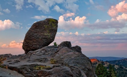
Yellowstone national park in Wyoming is world-famous for volcanic features such as geysers, fumaroles and mud springs, but northern California boasts its very own version: Lassen Volcanic national park, 50 miles east of Redding.
The park is capped by 10,462-foot Lassen Peak, the world’s largest volcanic dome. Lassen’s 1915 blast makes it one of only two volcanoes to have erupted in the continental US in the 20th century (the other being Washington’s Mount Saint Helens in 1980). After the eruption, which laid waste to vast swaths of surrounding land, Lassen Volcanic national park was created to preserve the devastated areas for future observation and study. Visiting the area now, nearly 100 years later, is a dramatic lesson in the Earth’s own healing powers; it still bears vast scars of hardened lava, but between the rocks, the flora and fauna are flourishing.
In the summer, Lassen offers over 150 miles of hiking trails to a wide range of volcanic features such as Sulphur Works and Bumpass Hell, the park’s largest hydrothermal feature. Despite all the underground heat, Lassen is also known for receiving epic snowfalls – sometimes 900 inches in one season! – that turn the park into a winter wonderland popular with snowshoers, cross-country and backcountry skiers. Lassen has eight seasonal campsites and rustic cabins are available at Manzanita Lake from May to October.
TOP TIP Sign up for a photography, geology or birding workshop through the non-profit Lassen Association’s Field Seminar Program at Lassen national park.
Lassen links hiking, camping and cabins, Lassen Association
Sequoia and Kings Canyon national parks
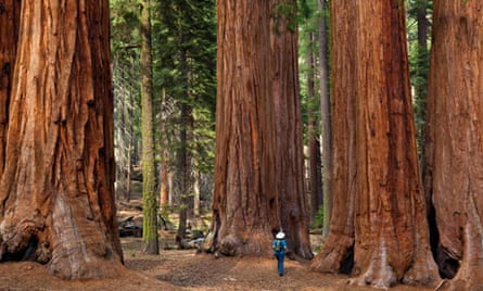
California has a lot of parks but you can cross two off your list at once by visiting Sequoia and Kings Canyon, just south-east of Yosemite. They are two distinct parks, but are co-managed and share a border and an entrance fee ($5 a head). Both offer lodges and campsites, but keep in mind that only a very small fraction of these remote and rugged parks are accessible by road. To really see them, you’ll need to take a hike.
Sequoia is home to the largest tree in the world, by volume. Redwoods are taller, but giant sequoias win for sheer mass: the General Sherman’s trunk has a volume of 1,487 cubic metres and is estimated to weigh over 2,000 tonnes. Sequoia also boasts 4,421m Mount Whitney, the high point of the John Muir Trail, which runs through Sequoia and Kings Canyon on its way up to Yosemite.
Kings Canyon national park protects the headwaters of the south and middle forks of the Kings river and the south fork of the San Joaquin river, two of the most picturesque and pristine rivers in California. The south fork section of Kings river – known as Kings Canyon, one of the deepest in the country, dropping down more than 2,500m – was carved out of solid granite by glaciers during the last ice age.
TOP TIP The Giant Forest in Sequoia national park is home to five of the 10 largest trees in the world, including the General Sherman. Pay your respects to these 3,500-year old sentinels along the 40 miles of trails that weave through the grove.
Sequoia and Kings Canyon links hiking, camping, lodging, John Muir Trail
Pinnacles national park
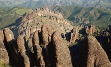
Until recently, these dramatic cliffs 40 miles southeast of Salinas were known as Pinnacles National Monument, but in January 2013 they became the nation’s newest national park. The massive spires and sheer canyons are actually the remains of an ancient volcano that was split in two by the San Andreas Fault and hauled 150 miles from its original location. The spectacular walls attract rock climbers as well as bats, falcons and one of the rarest birds in the world: the California condor . A type of vulture and the largest bird in North America, it became extinct in the wild in 1987 due to poaching, poisoning and habitat destruction. Captive breeding programmes have helped reintroduce dozens of the big black birds into parks in Arizona, Utah and California. At the last count, in 2012, this park was home to 32 wild condors.
Pinnacles has one campsite on the east side of the park, which is more developed than the western entrance. Roads run from the east and the west, but don’t connect in the middle, which helps keep the heart of Pinnacles wild.
TOP TIP Don’t miss Pinnacle’s unique talus caves, Bear Gulch in the east and Balconies Cave in the west. They formed when steep, narrow canyons filled with boulders, leaving passages between the rocks. The caves are home to colonies of Towson’s big-eared bats and may be closed during pupping season or after rains due to high water.
Pinnacles links condors recovery programme, climbing, camping, caves
Devils Postpile national monument
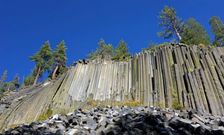
The Devils Postpile, near Mammoth Lakes on the east side of Yosemite, looks as if it might have been created by some satanic sculptor, but really it’s just one of the world’s best examples of columnar basalt, a similar geological feature to the Giants Causeway in Northern Ireland. The Postpile’s 18m columns were created when a mass of basaltic lava cooled at a relatively uniform rate. As the lava cooled and contracted, it split along joints into columns, most of which are pentagonal or hexagonal, with a few three, four, and seven-sided columns scattered throughout.
The half-mile walk from the campsite to the base of the Postpile is easy and the hike to the top takes only about 15 minutes of moderate uphill hiking. The John Muir and Pacific Crest Trails also pass through, and many through-hikers use the park as a place to rest and refuel before continuing to Canada or Mexico.
TOP TIP Definitely plan to put the extra effort into climbing to the top of the Postpile. The hike is only moderately difficult and is the best way to see the polygons end-on.
Devils Postpile links camping, geology, Pacific Crest Trail
King Range national conservation area
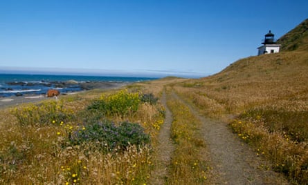
Look at a map of California and you’ll see that Highways 1 and 101 run along the entire coast, except for a 65-mile slice between Eureka and Rockport known as the Lost Coast. This section, protected by the King Range national conservation area, is the longest stretch of wild beach in California.
Since there are no roads into the Lost Coast, you have to walk to see it. A potholed gravel road runs to a campsite at the mouth of the Mattole river and from there you can wander south down the coast for 25 miles before you come to the next road, at Shelter Cove. The hike is mostly flat, but walking on sand with a pack is tiring and you’ll need tide charts to help navigate past the towering headlands. Bear canisters are required for all food, not just because of the bears, but also the seagulls, which will rob you of every last crumb.
TOP TIP The six-and-a-half-mile round trip trek from the Mattole river campsite to the elegant ruins of the Punta Gorda Lighthouse, built in 1912 and decommissioned in 1951, might be one of the most beautiful beach walks in the world. This area is also popular with surfers, though you’ll definitely need a wetsuit in these rough, cold waters.
Lost Coast links hiking trails, bear safety and canister regulations, history of the Punta Gorda lighthouse
Redwood national and state parks
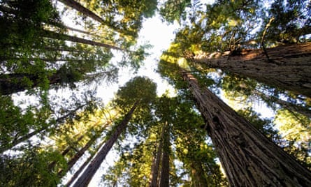
If you’ve been to Sequoia, you’ve already seen the largest trees in the world, but the Redwood national and state parks in northern California boast the tallest trees, including 115.7m Hyperion, the world’s tallest living tree. The exact location of Hyperion is a closely guarded secret, but standing at the base of any one of these giants is a truly humbling experience.
Giant redwoods once covered more than 5,000 square miles of coastal California, but as much as 96% of all old-growth redwoods were logged between 1850 and 1920, a staggering statistic that becomes even more tragic when you learn that redwoods are practically immortal and can live for thousands of years. Today, nearly half all remaining redwoods are found in these adjoining national and state parks.
Four developed campsites are scattered through the parks, but no indoor accommodation is available inside the park boundaries. Quaint lodgings can be found in the nearby small towns of Klamath, Requa and Orrick, with larger hotels in Crescent City, Arcata and Eureka.
TOP TIP Put a crick in your neck on the easy walking trails through the Ladybird Johnson Grove trail and Tall Trees Grove trail in the southern portion of Redwood national park.
Redwood links camping, the search for the tallest tree, Redwood canopy tours: northcoastadventurecenters.com and redwoods.info
Mary Caperton Morton is a freelance writer and photographer who makes her home on the back roads of North America, living and working out of a tiny solar-powered Teardrop trailer


Comments (…)
Sign in or create your Guardian account to join the discussion