How Innovative Mapping Technologies can Help Address Water Issues in International Development
|
There are many lessons to be learned from on-site organizations doing implementation.
As a personal account, I was recently reflecting on exploratory calls I conducted while at Results for Development (R4D). Water, sanitation and hygiene (WASH) organizations had a thing or two to say about how data and mapping technologies influence their work.
One trend I noticed was that innovative WASH organizations felt their voices were not being heard in Washington D.C. During the calls, they explained how they needed a new means of communicating with large donor and funding organizations. The solution? Data.
Data has caused a craze, a buzzword for new bandwagon technology enthusiasts. However, we must proceed with caution. Like a previous post on TechChange, The Case for Gender Data, research questions and our own cultural frameworks can easily slip in and create a biased data set, even with general survey assessments for water, sanitation and hygiene challenges.
From my experiences collaborating with organizations in South Sudan, Uganda, Kenya and India, similar themes presented themselves. The encroachment of new ‘innovative’ technologies and the cutthroat need for greater data collection has turned social good work into a narrow-minded desire to show off results rather than produce long-term outcomes.
Water quality and sanitation organizations feel the pressure to collect more data to prove their work’s success through the ‘x’ number of water pumps rather than ‘x’ amount of water being used. (Water Forever or Maji Milele translated in Kenyan, is a unique organization that addresses this issue through the sales of prepaid water meters to water utility companies in Kenya).
This means that maps need a skeptic’s eye, too. GIS applications have become a runner up in the bandwagon club. Maps are only as good as its data and the underlying story it tells. Too many maps in the field of International Development are merely tracking funding allocations and project placements rather than highlighting practical analysis tool sets to benefit socially marginalized populations.
Nonetheless, I have learned from working in this space that data collection, monitoring outcomes and mapping visualizations can most certainly help address water issues, but by no means is the solution.
Innovative technologies can help address the water and sanitation crisis but it’s not a ‘Silver Bullet’ Solution that will change broader social and political structures. It’s when these tools have real world applications to support policy and resource management that new mapping technologies are better equipped to get things done.
A great example of this is IWMI. International Water Management Institute (IWMI) is a pioneer in the field of international water and ecosystem management research. IWMI creates practical tools that are free and open to the public to help address water related issues through climate change vulnerability assessments, groundwater quality monitoring and water resource management.
These are three examples of mapping tools that are initiating a movement towards practical mapping applications with analysis that goes beyond just a point on the map.
“The Himalayan region is considered to be very sensitive to climate change due to the high variation in altitudes. Changes in cloud cover and rainfall, particularly over land; melting of icecaps and glaciers and reduced snow cover are some of the prominent threats due to rise in temperature. “
“The main objective of this study was to identify and prioritize sub-basins/watersheds in the Middle and High Mountains of Nepal that are significantly vulnerable to Climate Change (CC). ”
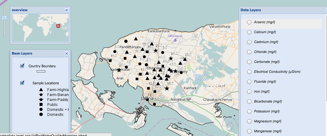
“The absence of perennial rivers or major water supply schemes to the Peninsula highlights the importance of groundwater as the predominant water resource for domestic, industrial and agricultural use. Intensive irrigation, higher inorganic fertilizer usage and a comparatively dense population may result in over-extraction of groundwater resources and a deterioration of the water quality over time.”
“The objective of this study was to characterize the chemical quality of the Chunnakam aquifer, map the spatial distribution of water quality and making the information easily accessible to future research studies and water/land-use managers.”
“The Water Information System for Sri Lanka aims to provide a web-based framework with access to information on water resources in Sri Lanka in order to ensure the sustainable use and efficient management of water resources. Information on Sri Lanka’s available water resources, how it is changing over time in quantity and quality, the present and future demand for water resources, and how climate change is impacting the overall situation of available water resources.”
If you’d like to learn more about mapping, I encourage you to sign-up for TechChange’s newest Mapping for Social Good certificate course and to join the conversation with me on Twitter at @EvaAdler44 and @TechChange.

Sedinam joined the the TechChange team to support service design and tech initiatives. She will be focusing on supporting partner...
TechChange recently broadcasted the Training Health Workers for Ebola webinar series, with the sponsorship and webinar content of mPowering Frontline...
Data is useless unless it provides us with actionable insights into our work. In order to make sense of the...