
Think this polar vortex was cold? It should have been colder.
Sure, it was icy. But over longer timescales, the science is clear: Cold snaps are getting warmer.
Now that the latest frigid, deadly Arctic blast is giving way to warmer conditions in the Midwest and Northeast, some clarity is emerging on how to think about cold waves in a warming climate.
An initial blizzard of headlines gave the impression that this week’s cold, driven by the weakening of the “polar vortex”—miles-high winds circling the North Pole—was a monumental event, and some accounts projected worse to come under global warming.
But many climate scientists focused deeply on the response of extreme winter weather in a human-heated climate see a different picture, explaining that data clearly show a long-term trend toward fewer, less widespread and less severe cold snaps of this sort. And the pattern is not limited to the United States.
Those background trends are a far more robust signal of human-driven planetary warming than any recent shifts in the behavior of the vortex.
This polar vortex in context
There’s been a predictable pattern around this issue since the winter of 2013-2014, when “polar vortex,” actually a decades-old meteorological term, first became something of a meme as a brutal cold snap and winter storm named Hercules captivated the media.
Since then, there’s been a tendency of climate campaigners, commentators, and news-hungry media to zoom in on the handful of pioneering, but tentative, studies finding that such outbreaks of cold air are worsening as a result of climate changes being driving by the atmospheric buildup of human-generated greenhouse gases.
The cold wave that swept from the Midwest through the Northeast in recent days set many single-day records in some cities and barreled across the country with jaw-dropping intensity. But it wasn’t remotely close to some truly monstrous cold waves in earlier decades.
On Thursday, Bloomberg’s Climate Changed team helped cut through the noise by citing the “cold-wave index” developed over more than 20 years by Kenneth Kunkel, a researcher at North Carolina State University who for three decades has studied extreme weather in the long-term context of climate. The index sifts weather-station data from across the country to estimate the duration and intensity of regional extreme cold spells, going back to 1895.
In an interview Thursday with National Geographic, Kunkel, who also works for the National Oceanic and Atmospheric Administration, rattled off some of the worst North Americans cold waves—1936, 1970, 1977, 1983, 1989, but he ended with 1996. “Nothing since then has approached the magnitude of those,” he said. “Since that time they’ve been kind of wimpy, really.”
And nothing from the 20thcentury on compares to what was called the Great Arctic Outbreak of February 1899, Kunkel said.

An array of similar findings can be found in the federal Climate Science Special Report of 2017, part of the latest Congressionally mandated National Climate Assessment.
According to the report, “The frequency of intense cold waves (four-day, one-in-five year events) peaked in the 1980s and then reached record-low levels in the 2000s.”
The geographic extent of winter cold spells has shrunk as well.


In 2016, the Environmental Protection Agency, as part of a broader set of climate change indicators, published a graph showing the declining percentage of the land area of the contiguous 48 states with unusually cold daily high and low temperatures during the months of December, January, and February.
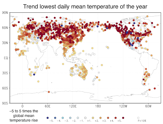
Global data show similar patterns. Using the Climate Explorer tool of the Netherlands Meteorological Institute, Cliff Mass, a meteorologist at the University of Washington and popular weather blogger, posted a map this week showing that, worldwide, the annual coldest daily temperatures recorded over the last 50 years have actually risen much fasterthan the overall pace of global warming.
The cold-warm connection
Many stories in recent days highlighted studies concluding that global warming is boosting odds of cold outbreaks—mainly the work of Judah Cohen, a commercial weather analyst specializing in long-term winter forecasts, and Jennifer Francis, a senior scientist at the Woods Hole Research Center in Massachusetts.
Independently, they’ve focused on relationships between the shrinking amount of the Arctic Ocean covered in floating sea ice and instances where the polar vortex weakens, allowing cold air to spill south and warm air to flow north.
Like all new science on an issue in the public eye, such work tends to get outsize coverage.
But that can distract from the reality that all research on a new knowledge frontier is tentative. In this case, a host of other scientists looking at extreme weather in the context of climate change have been far more cautious.
In a CBS News web story on the cold and climate change this week, Michael E. Mann, a Pennsylvania State University climatologist who’s become a prominent campaigner for cutting greenhouse gas emissions, stressed the need for caution on this question.
“The apparent increase in frequency of these events is quite recent and so at best only just starting to emerge from the background noise,” he said, adding: “As we showed in our recent Science article, current generation climate models don't resolve some of the key processes involved in the jet stream dynamics behind many types of weather extremes.”
In an email exchange Friday, Francis said, “It's absolutely true that fewer cold records are being broken than high-temperature records, which is totally consistent with a warming globe. But this new possible connection between Arctic warming and disrupted stratospheric polar vortex adds nuance to this story, albeit a complicated one that will take a while to verify—or not.”
She said that, initially, her “hypothesis got way more attention than it deserved for such a new concept.”
But she proposed that the intense public and media focus on winter cold snaps has raised the profile of such questions.
“People are experiencing and hearing about a lot more extreme weather, which everyone loves to read and talk about,” Francis said. “While we have their attention during these extreme events, if we can inject a bit of science (particularly climate science) about how some extreme events are being goosed by climate change, it's a very good teaching moment. Perhaps it's even helping to move the needle a bit in the new polls showing that there has been a sizable uptick in those who consider climate change to be important, worrisome, and largely human's doing.”
Related Topics


Go Further
Animals
- Octopuses have a lot of secrets. Can you guess 8 of them?
- Animals
- Feature
Octopuses have a lot of secrets. Can you guess 8 of them? - This biologist and her rescue dog help protect bears in the AndesThis biologist and her rescue dog help protect bears in the Andes
- An octopus invited this writer into her tank—and her secret worldAn octopus invited this writer into her tank—and her secret world
- Peace-loving bonobos are more aggressive than we thoughtPeace-loving bonobos are more aggressive than we thought
Environment
- This ancient society tried to stop El Niño—with child sacrificeThis ancient society tried to stop El Niño—with child sacrifice
- U.S. plans to clean its drinking water. What does that mean?U.S. plans to clean its drinking water. What does that mean?
- Food systems: supporting the triangle of food security, Video Story
- Paid Content
Food systems: supporting the triangle of food security - Will we ever solve the mystery of the Mima mounds?Will we ever solve the mystery of the Mima mounds?
- Are synthetic diamonds really better for the planet?Are synthetic diamonds really better for the planet?
- This year's cherry blossom peak bloom was a warning signThis year's cherry blossom peak bloom was a warning sign
History & Culture
- Strange clues in a Maya temple reveal a fiery political dramaStrange clues in a Maya temple reveal a fiery political drama
- How technology is revealing secrets in these ancient scrollsHow technology is revealing secrets in these ancient scrolls
- Pilgrimages aren’t just spiritual anymore. They’re a workout.Pilgrimages aren’t just spiritual anymore. They’re a workout.
- This ancient society tried to stop El Niño—with child sacrificeThis ancient society tried to stop El Niño—with child sacrifice
- This ancient cure was just revived in a lab. Does it work?This ancient cure was just revived in a lab. Does it work?
- See how ancient Indigenous artists left their markSee how ancient Indigenous artists left their mark
Science
- This 80-foot-long sea monster was the killer whale of its timeThis 80-foot-long sea monster was the killer whale of its time
- Every 80 years, this star appears in the sky—and it’s almost timeEvery 80 years, this star appears in the sky—and it’s almost time
- How do you create your own ‘Blue Zone’? Here are 6 tipsHow do you create your own ‘Blue Zone’? Here are 6 tips
- Why outdoor adventure is important for women as they ageWhy outdoor adventure is important for women as they age
Travel
- Slow-roasted meats and fluffy dumplings in the Czech capitalSlow-roasted meats and fluffy dumplings in the Czech capital
- Want to travel like a local? Sleep in a Mongolian yurt or an Amish farmhouseWant to travel like a local? Sleep in a Mongolian yurt or an Amish farmhouse
- Sharing culinary traditions in the orchard-filled highlands of JordanSharing culinary traditions in the orchard-filled highlands of Jordan
