File:Czechoslovakia 1939.SVG
Jump to navigation
Jump to search

Size of this PNG preview of this SVG file: 800 × 322 pixels. Other resolutions: 320 × 129 pixels | 640 × 257 pixels | 1,024 × 412 pixels | 1,280 × 515 pixels | 2,560 × 1,030 pixels | 1,059 × 426 pixels.
Original file (SVG file, nominally 1,059 × 426 pixels, file size: 104 KB)
Captions
Captions
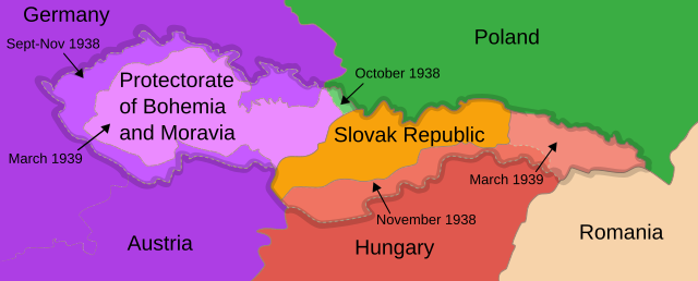
Czechoslovakia's borders in 1939
| Description |
English: Map of Czechoslovakia after 1939
Français : Carte de la Tchécoslovaquie aprés 1939
Русский: Карта Чехословакии после 1939 года
Українська: Карта Чехословаччини після 1939 року |
| Date | (UTC) |
| Source | For the info on the map it can be confirmed here: https://encyclopedia.ushmm.org/content/en/gallery/czechoslovakia-maps |
| Author | 16:36, 13 September 2007 (UTC) |
| Other versions |
Derivative works of this file: []
|


|
This SVG file contains embedded text that can be translated into your language, using any capable SVG editor, text editor or the SVG Translate tool. For more information see: About translating SVG files. |
| This is a retouched picture, which means that it has been digitally altered from its original version. The original can be viewed here: First Czechoslovak Republic.SVG:
|
This file is licensed under the Creative Commons Attribution-Share Alike 3.0 Unported license.
- You are free:
- to share – to copy, distribute and transmit the work
- to remix – to adapt the work
- Under the following conditions:
- attribution – You must give appropriate credit, provide a link to the license, and indicate if changes were made. You may do so in any reasonable manner, but not in any way that suggests the licensor endorses you or your use.
- share alike – If you remix, transform, or build upon the material, you must distribute your contributions under the same or compatible license as the original.
Original upload log[edit]
This image is a derivative work of the following images:
- Image:First_Czechoslovak_Republic.SVG licensed with Cc-by-sa-3.0
- 2008-06-09T15:42:55Z Themightyquill 1001x471 (403234 Bytes)
- 2008-06-08T23:43:55Z Themightyquill 1001x471 (68801 Bytes)
- 2008-06-08T23:40:33Z Themightyquill 1100x497 (68914 Bytes)
Uploaded with derivativeFX
File history
Click on a date/time to view the file as it appeared at that time.
| Date/Time | Thumbnail | Dimensions | User | Comment | |
|---|---|---|---|---|---|
| current | 19:47, 1 January 2020 | 1,059 × 426 (104 KB) | Chiswick Chap (talk | contribs) | enlarged text | |
| 14:30, 26 August 2010 | 1,059 × 426 (98 KB) | Themightyquill (talk | contribs) | |||
| 14:23, 26 August 2010 | 1,069 × 434 (97 KB) | Themightyquill (talk | contribs) | |||
| 04:42, 2 May 2010 | 1,069 × 435 (114 KB) | Themightyquill (talk | contribs) | Reverted to version as of 04:19, 2 May 2010 | ||
| 04:36, 2 May 2010 | 1,069 × 435 (114 KB) | Mnmazur (talk | contribs) | Reverted to version as of 23:15, 1 May 2010 | ||
| 04:19, 2 May 2010 | 1,069 × 435 (114 KB) | Themightyquill (talk | contribs) | Reverted to version as of 00:36, 1 May 2010 | ||
| 23:15, 1 May 2010 | 1,069 × 435 (114 KB) | Mnmazur (talk | contribs) | Very well, I've kept it a different color, but a color that's more related to the Polish color than the blue is. For a while, I had a hard time ascertaining who was actually annexing it, because unlike the purple of the Sudetenland and Germany, it's comp | ||
| 00:36, 1 May 2010 | 1,069 × 435 (114 KB) | Themightyquill (talk | contribs) | Reverted to version as of 13:38, 22 June 2008 - it wasn't broken - all the annexations are different colours to make it clear | ||
| 13:58, 30 April 2010 | 1,069 × 435 (114 KB) | Mnmazur (talk | contribs) | Fixing color of Polish annexation. | ||
| 13:38, 22 June 2008 | 1,069 × 435 (114 KB) | Themightyquill (talk | contribs) |
You cannot overwrite this file.
File usage on Commons
The following 29 pages use this file:
- Atlas of Czechoslovakia
- Atlas of Hungary
- Atlas of Slovakia
- Atlas of World War II
- Munich Agreement
- User:Magog the Ogre/Maps of conflicts/2020 January
- User:Themightyquill
- File:Czechoslovakia 1939.SVG
- File:Czechoslovakia 1939 be-x-old.SVG
- File:Czechoslovakia 1939 br.SVG
- File:Czechoslovakia 1939 ca.SVG
- File:Czechoslovakia 1939 de.svg
- File:Czechoslovakia 1939 es.SVG
- File:Czechoslovakia 1939 hu.svg
- File:Czechoslovakia 1939 it.SVG
- File:Czechoslovakia 1939 ka.png
- File:Czechoslovakia 1939 lv.svg
- File:Czechoslovakia 1939 no.svg
- File:Czechoslovakia 1939 ru.SVG
- File:Czechoslovakia 1939 sr.SVG
- File:Czechoslovakia 1939 sv.svg
- File:Czechoslovakia 1939 zh.svg
- File:Tchécoslovaquie 1939.SVG
- File:Territorial changes of Poland 1939c.jpg
- File:Československa 1939 cs.SVG
- File:Československa 1939 sk.SVG
- File talk:Annexation of Southern and Eastern Ukraine.svg
- Template:Other versions/Czechoslovakia 1939
- Category:First Vienna Award
File usage on other wikis
The following other wikis use this file:
- Usage on af.wikipedia.org
- Usage on ar.wikipedia.org
- Usage on be.wikipedia.org
- Usage on bg.wikipedia.org
- Usage on bs.wikipedia.org
- Usage on ca.wikipedia.org
- Usage on cy.wikipedia.org
- Usage on el.wikipedia.org
- Usage on en.wikipedia.org
- Czechoslovakia
- Irredentism
- Occupation of Czechoslovakia (1938–1945)
- History of Czechoslovakia
- List of irredentist claims or disputes
- Territorial evolution of Germany
- Territorial evolution of Poland
- Wikipedia talk:WikiProject Czech Republic/Archive 2
- Gauliga Sudetenland
- Gauliga Böhmen und Mähren
- Wikipedia talk:WikiProject Maps/Archive 5
- File talk:Nazi-Soviet 1941.png
- Wikipedia talk:WikiProject Slovakia/Archive 2
- The Holocaust in Bohemia and Moravia
- The Holocaust in the Sudetenland
- Usage on es.wikipedia.org
- Usage on et.wikipedia.org
- Usage on fi.wikipedia.org
- Usage on fr.wikipedia.org
- Usage on he.wikipedia.org
- Usage on hr.wikipedia.org
- Usage on hu.wikipedia.org
- Usage on id.wikipedia.org
- Usage on it.wikipedia.org
- Usage on ja.wikipedia.org
- Usage on ka.wikipedia.org
- Usage on ko.wikipedia.org
View more global usage of this file.