The below drawing might not look that unusual, albeit fairly obviously from an older time when the riverside was still a major port and industrial centre, but at the time it was printed – in 1886 – it was quite radical.
The reason it stood out is that at the time, Tower Bridge didn’t exist!
The picture, taken from my collection of The Graphic newspaper of June 1886 is actually a representation of what the area will look like eventually, mainly to explain to a still sceptical public what the benefits of a bridge at this location would be.
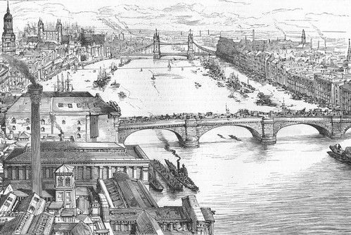
Means of Communication between the North and South sides of the Thames below London Bridge, showing the advantages afforded by the new bridge A. Thames Tunnel B. Tower Subway C. The New Tower Bridge
Notice the line marking the existence of the Tower Subway next to the future Tower Bridge, the earliest tube railway in London, pre-dating even the City & South London Railway (now the Northern Line) – although the railway component lasted just a couple of years, and it later became a pedestrian tunnel.
The use of the subway tunnel by pedestrians collapsed after Tower Bridge opened, and it was eventually sold as a mains water supply tunnel for hydraulic power to the City. It is still there, although now used to carry fibre-optic cables.


That’s an exceptional find, Ian. I can’t work out what’s going on on the north bank, though. The river seems to step back significantly behind the foreground warehouses, and what looks like the tower of St Magnus is shifted away from it’s place almost on top of the bridge. I’m looking on an iPhone screen though, so might be my limited view.
The northern side does seem set further back than usual, but the embankment that runs along it now isn’t there which could account for some of the offsetting.
I’d guess they might have been working off architects impressions, which never ever exaggerate the impressiveness of their construction 😉
I also wonder if the apparent “lack” of sailing ships in the river upstream of the bridge compared to how I imagine it probably actually looked at the time was deliberate?